
Ask a Grade 7 class to mark the world’s hot deserts on a blank map and most of them will do it well. Then ask why those deserts sit in two belts, roughly 30 degrees north and south of the equator. The room usually goes quiet. Sometimes one student says, “Because it’s hot there.”
That silence doesn’t mean the students are weak. It shows how the curriculum was ordered. They were taught the pattern, where the deserts are, without the process that explains it: sinking dry air in the subtropical high-pressure belts. Without the process, the map is just a picture to memorise.
Patterns are what students see. Processes are what explain them.
Physical geography has two layers. The top layer is patterns: where mountains, deserts, floods and coastlines are found. Underneath is processes: weathering, erosion, deposition, atmospheric circulation and the water cycle. A curriculum that only teaches the top layer produces students who can describe the world but can’t reason about it.
The Ofsted geography research review separates knowledge of places and locations from knowledge of physical and human processes. It argues that content should be sequenced so that earlier learning prepares pupils for more complex ideas later. The review was written for schools in England, so its examples don’t transfer directly. The principle does: a process taught early becomes a tool students can use again with every new landscape.
What a process-first sequence looks like
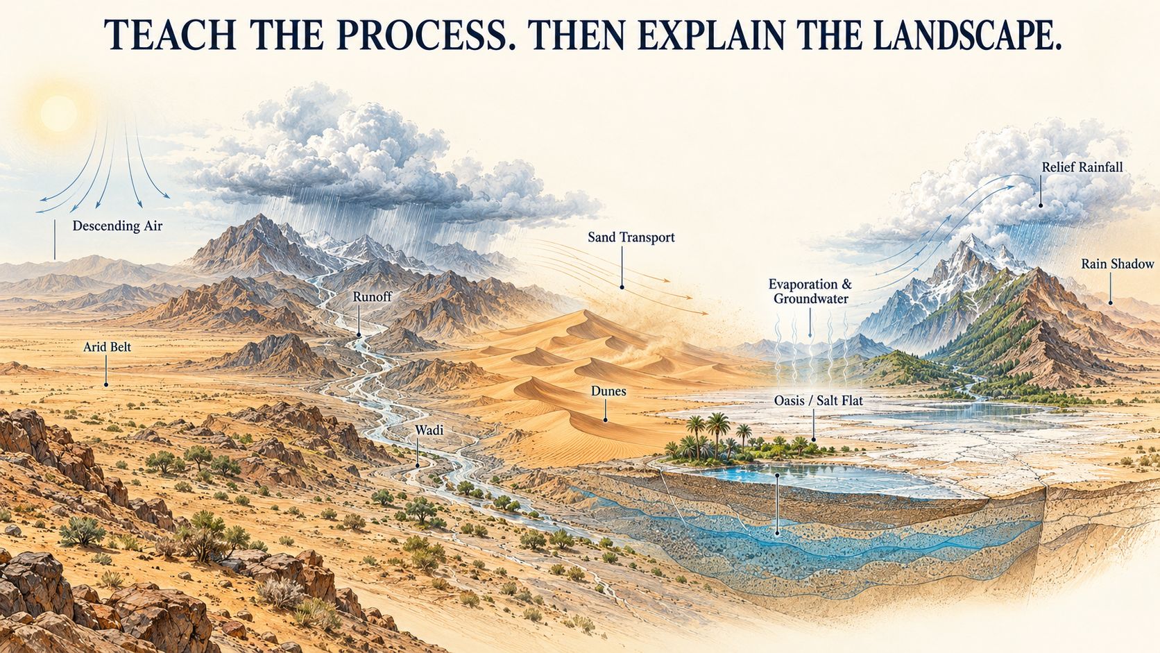
In a process-first sequence, students learn why something happens before they are asked to describe where it happens. Hot deserts are a good example. They form two belts near 30 degrees north and south because dry air sinks in the subtropical high-pressure zones, so global air circulation should come before climate zones, not years after them. In the same way, the dry valleys known as wadis, which flood suddenly after a short, heavy storm, make sense only once students understand rainfall intensity, hard ground and fast surface runoff. That means the water cycle belongs before any lesson on flood hazards.
The same logic applies to other desert landscapes. Sand dunes take different shapes depending on the prevailing wind direction and how much sand is available, so they are best taught after weathering and wind erosion. Coastal salt flats form where evaporation is high and the water table is shallow, which fits naturally after the water cycle and alongside coastal study. Mountain slopes get more rain than the plains below because of relief rainfall, and students need that idea before they study farming and settlement patterns.
Some of these processes matter well beyond geography. Oases and older towns grew where groundwater, aquifers and springs made life possible, so groundwater should be taught before students meet settlement and trade routes in history. If students learn it first, the history lesson becomes an explanation rather than a list of places. Several physical geography processes turn out to be prerequisites for lessons in other strands. We cover this in more detail in [Blog 19 | Finding Missing Prerequisites in a Social Studies Sequence | Linked text: “auditing social studies curriculum sequencing”].
Start with the landscape students live in
Students in arid environments have evidence in front of them every year: warnings about flash floods after a short storm, dust in the air before a season changes, heat that stays in the city long after sunset. A good sequence uses these experiences as the first case study, not as a local footnote after rainforests and glaciers.
Local doesn’t mean narrow, though. Once students understand why their own dry valley floods, they can transfer that reasoning to a monsoon river basin or a mountain glacier. That transfer is the real sign of progress. We describe it in [Blog 44 | Mapping Geographical Thinking From Primary to Secondary: A Progression Model | Linked text: “geography curriculum progression”].
Three sequencing mistakes to look for
The landform gallery. Each lesson introduces a new feature (a delta, a dune, a volcano) with its definition and a photo. Nothing links one lesson to the next.
Climate zones before circulation. Students memorise a coloured world map of climate zones years before they learn why the colours fall where they do.
Processes saved for high school. Younger students only get names and pictures, and processes arrive suddenly in Grade 9. Simple process thinking can start much earlier. A Grade 3 student can see that water runs faster off concrete than off sand.
This matters because physical geography is the base for the bigger questions students meet later: water security, sustainable cities and climate adaptation. We argue this in [Blog 43 | What Makes Geography Learning More Than Knowing Places? | Linked text: “geographical thinking curriculum”].
A question for curriculum teams: